
"Eminence is located in the center of the Ozark National Scenic Riverways, Missouri's largest national park and the nation's first protected river system. Popular activities in the Eminence area include canoeing, hunting, fishing, and horseback riding. "Eminence maintains a small town feel, but in the summer becomes a resort city with several locally owned restaurants, motels, bed & breakfasts, including America's largest trail riding establishment." Source: Wikipedia
From Joplin, MO, we took I-44 East to Springfield and then Route 60 East to Winona and then north on Missouri 19 to Eminence. Actually a pretty nice drive of 204 miles (about 3 hours).

On our way to Eminence, Missouri

Nancy provided a folding chair for my entry into
the Jack Fork River, which was just below our
cabin in Eminence.
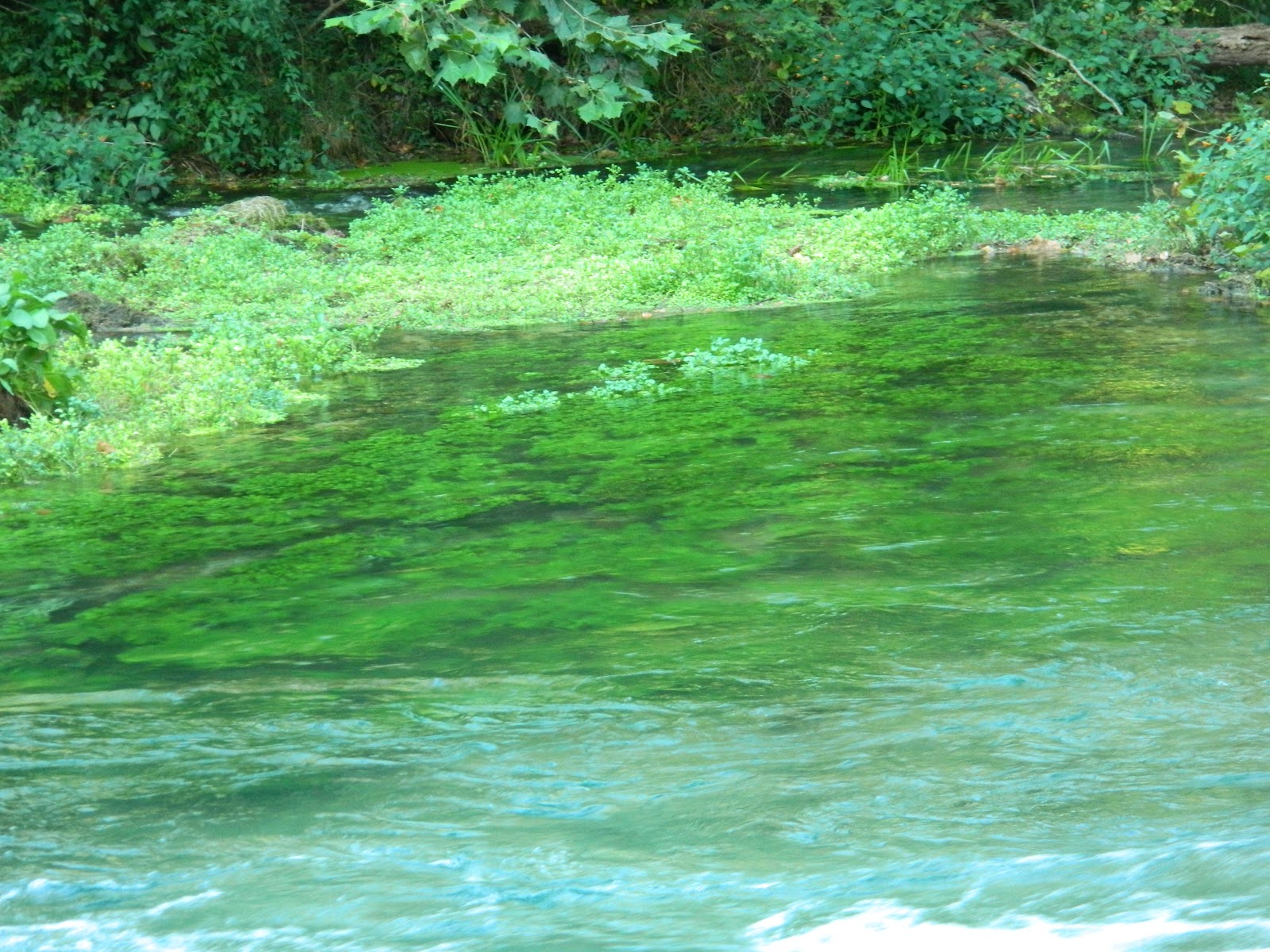
 |
| Notice how crystal clear the water is! As I sat there, fish from 2 inches to 8 inches swam around me. |
 |
| Nancy ventures out into the cool clear water. The riverbottom and shore was gravel -- no sand. |
 |
| Nancy had a great time, I think, floating/walking out in the river. Getting me into the "cool" water was much more difficult. |
 |
| The sun was shining and the weather was warm -- ideal for a riverwalk. |
 |
| Jack's Fork River"Jacks Fork[1] is one of two rivers in Missouri that are part of the Ozark National Scenic Riverways system. Starting in Texas County, Missouri, this spring-fed river flows 46.4 miles (74.7 km)[2] in a general east to northeasterly direction through the heart of the geological area known as the Lower Ozark Natural Division. It is the major tributary of the Current River, ending at its confluence near Eminence, Missouri. The first 25 miles (40 km) from the Prongs to Bay Creek is deep valley and in the springtime provides Class II water. Due to lack of access, it is the most primitive of the rivers in the region. From Alley Spring to its confluence with the Current River it is a Class I River and is floatable year around with warm water. The Jacks Fork provides some of the most natural conditions in the region with many caves and natural springs. It is a popular recreation destination for canoeists and kayakers and is generally considered a Class I-II difficulty river." Source: Wikipedia |
 |
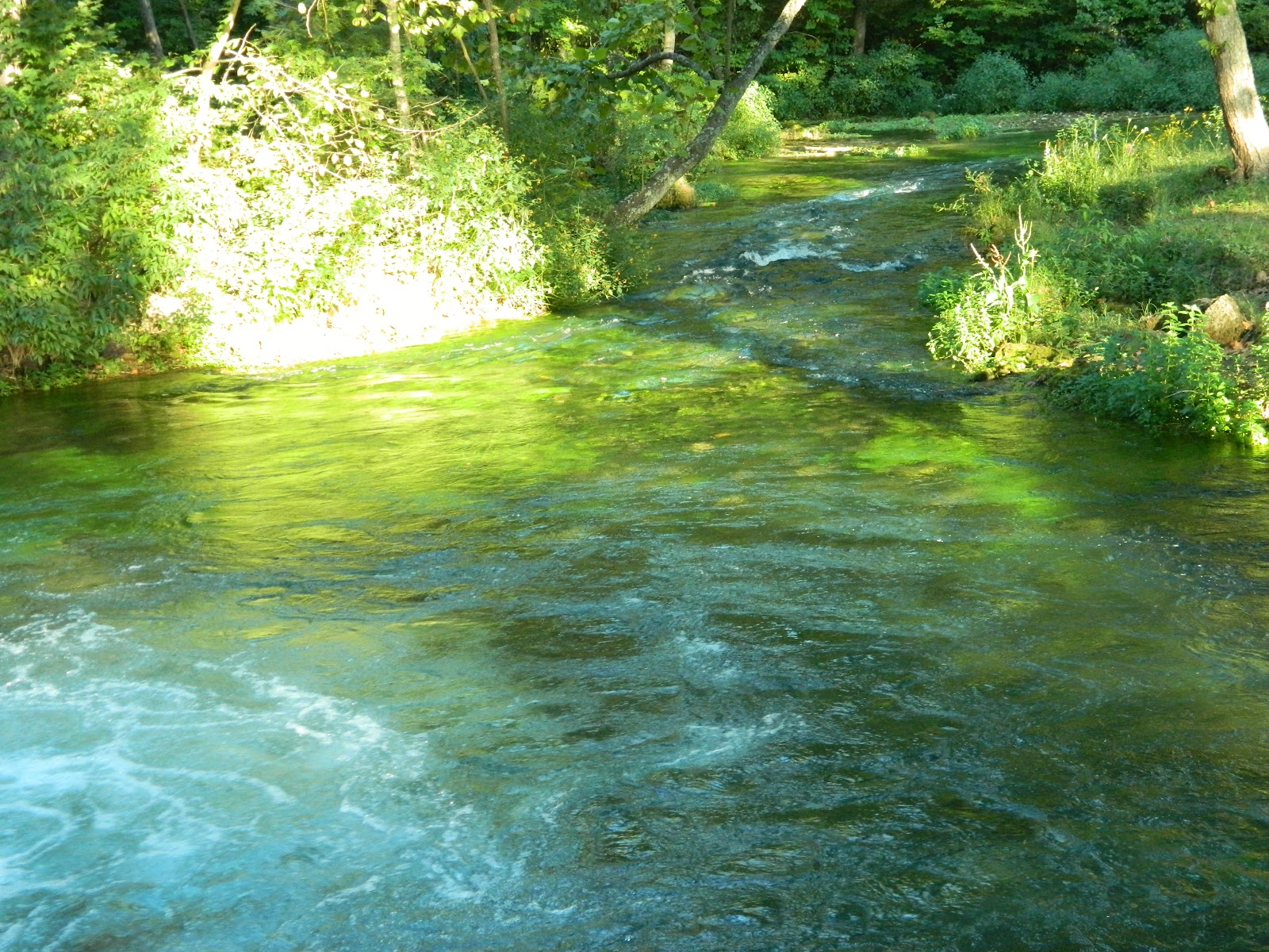
| Since we found our way into Jack's Fork at the end of August, the water was only waist deep to 10 feet deep. The drought hasn't helped, either. |
 |
| Nancy was in her element on Jack's Fork River. |
 |
| About 6 p.m., we drove east about 6 miles to Alley Mill Spring. "Alley Spring is an unincorporated community in Shannon County, Missouri, United States. It is located six miles west of Eminence on Route 106. The scenic Alley Mill, or "Old Red Mill" is located there on a spring and is located in the Ozark National Scenic Riverways. The Mill is operated as an Ozarks history museum. Nearby a one room schoolhouse and general store add to the feeling of the restored historic hamlet. It once had a post office, but it is now closed and mail now comes from Eminence. The community is named after John Alley, a miller. It was originally named Mammoth Spring and later Barksdale Spring. These names were deemed too long by the Post Office Department of the time, so the village was renamed after a prominent local citizen, John Alley." Source: Wikipedia |
 |
| The walkway for fine gravel -- a challenge for the old man and Nancy. |
 |
| What a sweet couple! Notice our car in the background. There were only two other cars in the big parking lot. |
 |
| "Alley Spring is a well known spot for family reunions, picnics, campouts and fishing trips. It became part of Ozark National Scenic Riverways in 1969. Ten thousand years ago, the Ozarks looked quite a bit different. In this region these early Indians hunted the abundant game and fished the rich waters of the nearby rivers. Alley was an almost perfect place to camp for these original Ozarkers. (Nephites?) "In the 1830s and 1840s, European settlers from Tennessee and other areas began to homestead in the region. The rivers and springs of the Ozark Riverways area attracted them just as they had the Indians centuries earlier." Source: Wikipedia |
 |
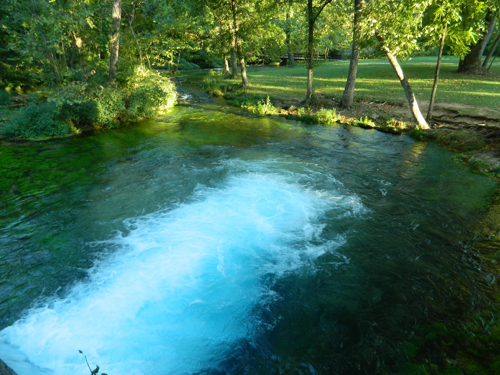
| On average, 81 million gallons of water flow out of Alley Spring, but only a portion of that through this gate. |
 |
| "Alley Spring, the natural area’s namesake, is the seventh largest spring in Missouri. The spring conduit is known to extend at least 3000 feet underground and reaches at least 155 feet below the surface. Rainfall and runoff entering sinkholes around the town of Summersville, 15 miles to the northwest, has been determined to enter the labyrinth of cave passageways formed in dissolved dolomite ( a type of limestone) under the Missouri Ozarks and exit at Alley Spring." Source: Missouri Department of Conservation |
 |
| The water coming out of the spring is crystal clear blue. |
 |
| The bottom of the stream coming out of the spring is covered with watercrest. There isn't much algae in the water, which flows out of the spring at about 58 degrees. |

 |
| Nancy and I felt like we were in a part of the Garden of Eden, though maybe it was actually The Waters of Mormon. |

 |
| Access to Alley Mill and Spring were marvelous -- well, at least up to the mill area. |
 |
| Nancy followed the trail next to the spring to get a look down into the crater. |
 |
| A rock cliff abutts the spring on the north edge. |


 |
| Nancy followed this trail on the west side of the spring. |


 |
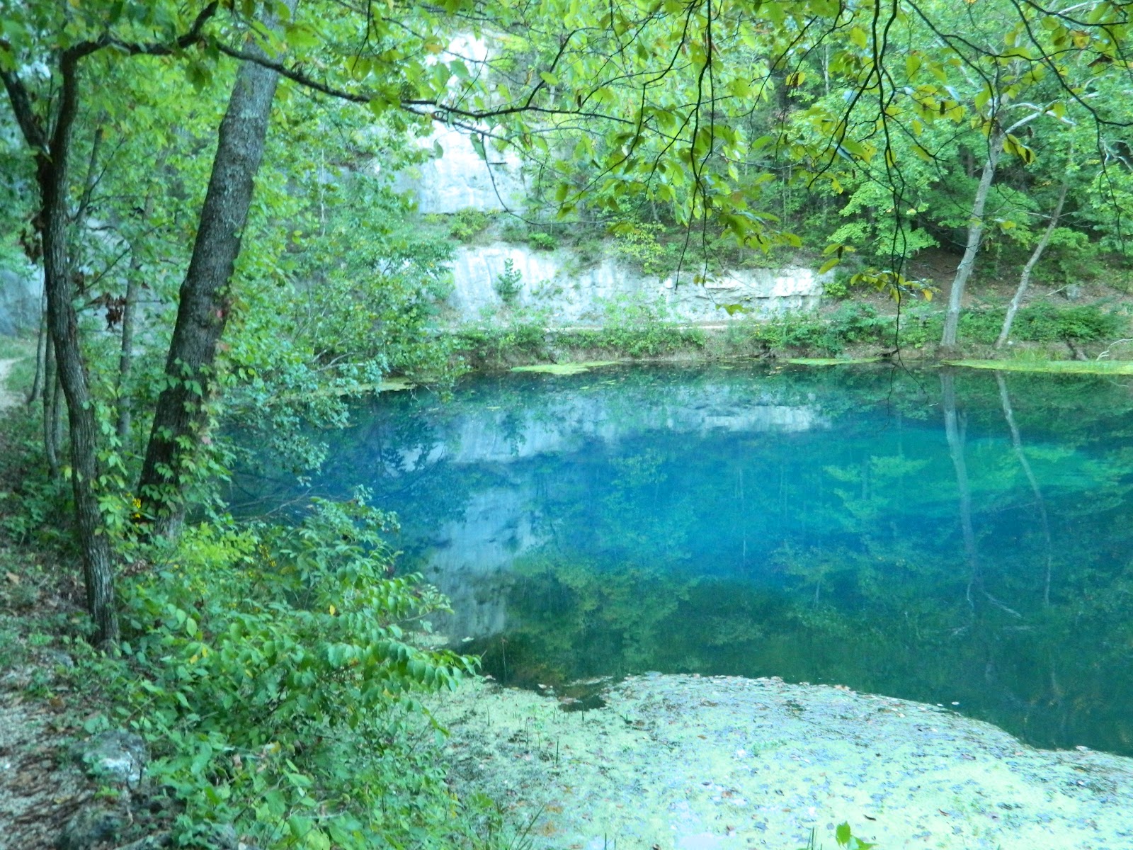
| Notice the incredibly blue water and all the foliage reflections. |
 |
| What's real and what's a reflection? |


 |
| These two caves and the crack in the stone below them create a happy face! The caves are about 10 feet above the spring trail at the northern edge of the spring. |


 |
| "It wasn't until 1894 that the current Alley Mill was built by a local speculator, George Washington McCaskill and his business partner, Jenoah H.(J.H.)Whitacre, their names are still seen engraved on the siding next to the entrance. With a turbine rather than a water wheel, and with rollers rather than stone grist stones, it was considered to be very "high tech" for its day. It served the needs of the local community by processing the farmers' grain. As flour or meal it could be sold or bartered for goods and services. In time, other services became available at Alley, including a blacksmith, a general store, and a school." Source: Wikipedia |

 |
| Now we're south of the mill, looking north at the water flowing out of the spring. |

 |
| A giant Sycamore tree to the south of the mill. I wonder how old it is? |

 |
| The Sycamore tree has some pretty strange branches. |
 |
| A trail southeast of the mill took us to a bridge over the stream below the spring. |
 |
| Turtleman tries his luck on the wood bridge. |
 |
| The most striking thing about the stream was how clean and clear the water was. |


 |
| Looking northwest at the water flowing past the mill. |


 |
| Nancy left me back at the base of the bridge and followed the trial up to another spring vantage point. |
 |
| From across the stream and south of the spring, Nancy found the other spring outlet. |


 |
| The water from Alley Spring eventually flows into Jack's Fork River, which is the river in which Nancy frolicked. |
 |
| On Friday morning, we headed north on MO-19 to another spring: "The Round Spring area is home to a family campground, a picnic area, a tour cave and the spring from which it takes its name. Round Spring was a Missouri State Park from 1932 until 1964 when the people of Missouri donated it to the National Park Service to become one of the star attractions of the new Ozark National Scenic Riverways. Like Alley and Big Spring, it was a gift from Missouri to the nation." Source: National Park Service |
 |
| Notice the different eras mentioned on the mural: Could the Woodland era be the Nephite era? |

 |
| The blue waters of Round Spring. "The spring itself is some 55 feet deep, rising in a nearly circular pool of water before flowing under a natural bridge, eventually joining the Current River." Source: National Park Service |

 |
| Nancy stands on a ledge between the spring and the outlet into the stream. |
 |
| The drop is at least 20 feet straight down just off where Nancy's shadow is seen. |

 |
| Now we're headed back to Eminence, our staging area for all the Spring visits. |
 |
| Nancy loved the welded sculptures and flower arrangements in front of River's Edge cabins and just down the path from ours. |
 |
| The welded tree in the center has a trumpet vine that has followed the welded branches above. A morning glory in bloom is wrapped around the "truck" of the "tree." |
 |
| The welded sculptures and flowers were a welcoming feature for guests at River's Edge in Eminence, MO. |


 |
| The welder's workshopl and his handywork at River's Edge. |
 |
| Our cabin had an incredible view and access to Jack's Fork River, though the cabin itself wasn't worth the price. Ours was part of Riverside complex, but, in my opinion, River's Edge cabins looked a lot newer and nicer. |
 |
| After a quick stop at our cabin, we headed to Blue Spring: At the only warning light in Eminence, we turned east and followed Highway 106 for 16 miles, crossing the Current River just after it merges with Jack's Fork River. Then we followed the signs, turned right onto a dirt road and drove three miles to the parking lot for the trail to Blue Spring, right next to Current River. |
 |
| The dirt road is a beautiful drive but a little bumpy. I wouldn't do the road during a rainstorm or after one! |

 |
| We came upon a slow mover on our drive to the spring. Nancy jumped out and took some pictures. |
 |
| Between each picture, she had to retrieve the turtle from the grass on the side of the road for another one. |
 |
| His head points the way -- off the dirt road! |
 |
| We weren't sure what the quarter-mile trail to Blue Spring was going to be like, so I started walking, and Nancy pushed my wheelchair in case we found a suitable pushing area down the path. About half way (I was still walking), I came to an area of tree roots and a steep incline, plus rock steps. So I stayed there next to the river and Nancy went on and came upon ... |
 |
| ... this deep and blue spring -- "the 6th largest spring in Missouri with a discharge of 90 million gallons per day. The azure Blue Spring is Missouri’s deepest known spring (300 feet). |
 |
| The water from Blue Spring flows into Current River. |

 |
| The rock ledge below the water isn't a reflection. |

 |
| After taking pictures of the spring, Nancy found another trail that took her up above the spring. |


 |
| Blue Spring water flowing into the Current River. |


 |
| Bath along the trail to Blue Spring leads down to the Current River. |


 |
| Water from Blue Spring, left, enters the Current River. |
 |
| My view of the current River where I waited for Nancy to return from Blue Spring. |
 |
| Nancy spotted this berry "tree" along the dirt road to Blue Spring as we were headed home. Looks like a grape vine, but it really was more like a tree with clusters of grapes or .... you tell me!!! |
 |
| Wild grapes or what? |
 |
| Nancy waves at me sitting in the car after we stopped at the Powder Mill campground upstream just north of where the Blue Spring branch empties into the Current River. |
 |
| Nancy walks back from the Current River where I've parked the car under a huge River Birch tree. The branches of the tree streach halfway across to the river. |
 |
| As Nancy and I headed back toward Eminence, MO, the clouds from Hurricane Isaac start to build up into our area. |

 |
| On our way back from Blue Spring and west of Powder Mill Campground, we made another stop -- this time at Rocky Falls.
"Nine miles southeast of Eminence on Highway NN is one of the finest examples of shut-in geology in the state: Rocky Falls Shut-in. A shut-in is formed when a stream encounters tough igneous rock. While water can easily wear down limestone or other sedimentary rocks, it meets its match in the highly resistant brown, pink and purple porphyry that are remnants of ancient volcanic activity. The result is a dramatic and musical water show, which in this case is as much a waterfall as a shut-in. Rocky Creek cascades 40 feet down the rock, finally finding freedom in a wide pool of cold, clear water that is an excellent if little-known swimming hole." Source: Rural Missouri
|
 |
| When we arrived at the falls, there wasn't much of a show because it was late August and because much of southeastern Missouri has been suffering from drought conditions. There still was a nice clear pool of water, which a group of young people were enjoying. |
 |
| Only a small stream of water was cascading down Rocky Falls. |
 |
| In the southeastern end of the pool, we spotted some water lily pads. |

 |
| As soon as we arrived back at our cabin back in Eminence, Nancy headed down to the Jack's Fork River. I drove the car down and relaxed by the shore and captured some closeups of the flowers still blooming this late in the summer. |


 |
| Then I spotted a "mermaid" in the shallow part of the river. |
 |
| Then the "mermaid" was surprised by a pair men in a canoe. |
 |
| We left the river and went back into our cabin at about 5:30 p.m., planning to go to a Blue Grass Festival nearby. Within a half an hour, we were hit by a wind and rainstorm. We decided to pack up and head home in case it got worse. When we got no farther than 30 yards away from our cabin, we came upon this roadblock. |
 |
| The windstorm had tossed a couple of large branches from a tree into the road. We thought we might have more problems heading home, but we didn't see much of any rain all the way home. |
 |
| However, we did see some beautiful sunsets as the clouds from Isaac kept moving north from Louisiana. |


 |
| We felt these last two pictures were a perfect ending to a beautiful adventure in paradise. |
WOW! Oh WOW!!! That is a heavenly place for sure!! I Can't wait to see it!!! There are some beautiful photos you guys took too. I can't wait to be in that part of the country!! I need the green and the water! If I can't have the ocean I want that! Oh and you need to put a link to the website and the nephite theory that you're eluding to throughout the post. It is http://www.bookofmormonevidence.org/
ReplyDelete